Nation Building in the Niagara Region
The Niagara region has played host to some of the most monumental events in Canadian history. Explore key heritage sites in Niagara where many risked their lives to build the great nation of Canada.
Explore Niagara’s Heritage sites
From famous battles during the War of 1812 and the Fenian Raids, to the construction of turn of the century hydroelectric power stations, the Niagara region has played host to some of the most monumental events in Canadian history. Explore the theme of nation-building by visiting significant battlefields, feats of engineering, plaques and memorials to learn about the people who directly contributed to building the great nation of Canada.
Battles and War Memorials

Old Fort Erie
(Fort Erie)
Fort Erie was the first British army fort built in Ontario in 1764 while Pontiac’s Uprising was underway and saw service during the American War of Independence. The little Fort located on the edge of the Niagara River was badly damaged by storms and was replaced by the fort you can visit today.
This fort saw heavy fighting during the War of 1812. In fact, the heaviest fighting of that war and in the entire history of Canada took place in and around Old Fort Erie. After American forces attacked the fort in May 1813, British and Canadian troops dismantled and withdrew from the region. By late 1813, extraordinary efforts of the British army and its allies forced the American army back across the Niagara River and the fort was rebuilt. However, on July 3, 1814, another American force crossed the Niagara River and captured Fort Erie.
By the end of July 1814, after fighting the Battles of Chippawa and Lundy’s Lane, the British army and its allies forced the American army to retreat to what had become the American side of the Niagara Falls. They heroically took back Fort Erie.
The Fenian Raids
The Americans were not the only group to attack Fort Erie. Between 1866 and 1870, the Fenian Brotherhood, an Irish Republican organization, launched a series of raids into Canadian territory to pressure Britain to withdraw from Ireland. Most Fenian troops were experienced soldiers, having served in the Federal or Confederate armies in the recent American Civil War. Armed with surplus American Army weapons, the Fenian Brotherhood gave Canadian provinces a terrible shock during the Fenian Raids. The fear generated by the Fenian raids helped lead to the Confederation of Canada in 1867.


Mather Arch
Mather Arch is a monument to peace and friendship between Canada and the United States. Alonzo C. Mather donated the land and donated the funds to build this important landmark next to the Peace Bridge. The town’s cenotaph honouring the fallen of the last century is located on the grounds of Mather Arch park.
Battle of Chippawa
The Battle of Chippawa, fought on July 5, 1814, took place on the fields of Samuel Street’s farm, near the banks of the Niagara River. It began when a British, Canadian and Indigenous force of about 2,000 men, under Major-General Phineas Riall, attacked an invading American army of about 3,500 men, under Major-General Jacob Brown.
The fighting started early in the morning and lasted until nearly six o’clock in the evening. When it was over, the British were forced to withdraw and the Americans won the day. Three weeks later, however, the invaders were turned back at the bloody battle of Lundy’s Lane, fought on July 25, 1814.


Battle of Lundy’s Lane
The battle occurred on July 25, 1814, on what was a rise of clear farmland surrounded by an orchard and forest situated upon Lundy’s Lane. The six-hour-long battle was one of the bloodiest battles of the War of 1812. Lundy’s Lane was the site of a major battle between the British and American forces in which the Americans, after their victory at the Battle of Chippawa, attacked the British defensive position they had taken up. Following a bitterly contested engagement in the dark, the Americans withdrew.
Brock’s Monument
Queenston Heights is the location of one of Canada’s most famous battles where Major General Sir Isaac Brock, Commander-in-Chief of the British forces in Upper Canada, made the ultimate sacrifice of his life to lead only 200 troops to fight the Americans. With over 1000 American troops crossing into Upper Canada through Queenston Heights, this was a downwards battle from the start. Major General Sir Isaac Brock’s heroic and selfless leadership in protecting and preserving Canada during the Battle of Queenston Heights in the War of 1812 led to a disheartening loss of the battle but created the momentum to win the war. Fighting to protect Niagara, Major General Brock’s heroic leadership and courage is commemorated with a monument that marks his final resting place.

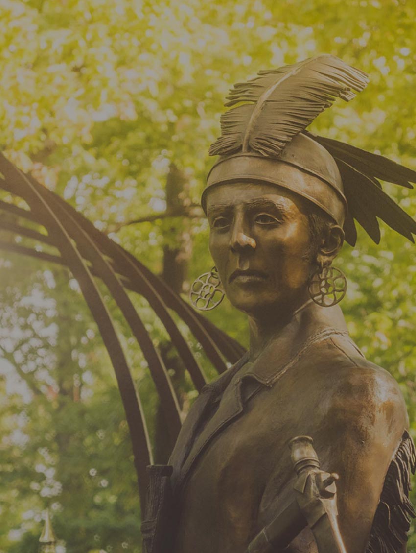
Landscape of Nations
The Landscape of Nations Memorial is dedicated to the Haudenosaunee (Six Nations) Confederacy and Indigenous allies that participated in the War of 1812. Limestone from the Queenston Quarry represent each nation of the Haudenosaunee Confederacy in a sunburst pattern. Anishinaabe, Abenakis, Delaware and many other nations are also honoured in the memorial. The Landscape of Nations Memorial affirms the proper place of First Nations peoples at the core of Canadian history and signals their ongoing role in contemporary life and national affairs.
Brock’s Cenotaph
This cenotaph at the base of Queenston Heights is near the location where Major General Isaac Brock fell in battle. He died in the battle on October 13, 1812, while advancing to repel the invading enemy. This cenotaph was unveiled by the Prince of Wales and future Edward VII during his visit in 1860 and is a place to honour and remember the bravery of Major General Isaac Brock.


Fort George
Located in Niagara-on-the-Lake, Fort George was built between 1796 and 1802. Fort George served as the headquarters for the British Army in Upper Canada during the War of 1812 and played a pivotal role in the defence of the Province.
Fort George saw action during the Battle of Queenston Heights and was captured by American troops during the Battle of Fort George in May 1813. Less than seven months later, the British and their allies successfully reclaimed the fort which became an unparalleled lookout location that helped win the War of 1812 and build the nation of Canada.
Butler’s Barracks National Historic Site
Butler’s Barracks is a historic military complex located southwest of Fort George in Niagara-on-the-Lake. Moving inland and out of range of American guns, Canadians built this military complex to replace the destroyed forts in Niagara during the War of 1812. By 1854, there were 20 buildings situated on the site, which became known as Butler’s Barracks. The surviving structures of this 19th century complex that can be seen today are the commissariat stories, the junior commissariat officers’ quarters, the men’s barracks and the gun shed.
In 1871, the barracks and the surrounding commons became training grounds known as Camp Niagara. During both World Wars, Butler’s Barracks was used to house and train Canadian service members headed for Europe.


Memorial Clock Tower and Cenotaph of Niagara-on-the-Lake
The Memorial Clock Tower, located in the heart of Niagara-on-the-Lake, is a memorial to the town residents killed in action during the First World War. It is a unique structure designed by Charles M.Wilmott, a noted Toronto architect and member of the Royal Architectural Institute of Canada.
Building the Nation
Niagara River and Welland Canal
The first Welland Canal opened in 1829 under the leadership of 1812 veteran William Hamilton Merritt and linked the two great lakes at either end of the Niagara. This bypassed Niagara Falls but still used much of the upper river for the movement of ships. The parkway along this section of the river is very close to the water and for a few years teams of oxen towed ships up the river after they exited the canal at Chippawa.


Development of the railroad
Around the same time as the construction of the Welland Canal in 1829, the first railroad in Ontario opened linking Queenston to Chippawa and was known as the Erie and Ontario because it connected those two Great Lakes. This followed the old portage route and like the new canal it went around Niagara Falls. Beginning in 1835, this railroad was initially used to haul goods and predated the arrival of steam engines with the cars or ‘trucks’ pulled by horses. By 1853 there was a line that ran all the way to Lake Ontario at Niagara-on-the-Lake and in 1864, another line went to Fort Erie.
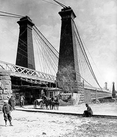
The Great Western Railroad initially ran from Hamilton to London Ontario and connected Lake Ontario to the Thames River. Just as the Queenston to Chippawa line covered a gap in water transportation, this railroad covered the overland route between two larger bodies of water. By 1853, the route expanded to Niagara Falls and was connected to New York State when the suspension bridge over the gorge had a railroad level added above the carriage and pedestrian level. By the 1880’s, railroads crisscrossed the Niagara Peninsula and more railway lines crossed the river to New York including the International Railway Bridge connecting Fort Erie and Buffalo. Opened in 1873, it is the oldest bridge still used on the river.
The Suspension Bridge
As rail lines were arriving in Niagara for the first time, we needed to bridge the mighty Niagara. By 1848, a designer by the name of John Roebling had the plans and materials in place to create a suspension bridge. After his work in Niagara, Roebling would go on to design the Brooklyn Bridge. Using the skills of a kite flying contest winner, 16-year-old Holman Walsh, a line was strung across the narrowest part of the river. The young kite flyer’s string was caught up in a tree, a thicker line was attached and pulled across the roaring rapids 300 feet below. Progressively the lines became larger and more numerous until a few weeks later, a suspension bridge spanned the Niagara gorge. The bridge was improved with the addition of the railroad level in 1855 and in 1894 a new steal arch bridge replaced the earlier suspension bridges in the same footprint. That bridge is still in use today and is known as the Whirlpool Bridge. More and more bridges would span the river and we built seven more bridges spanning the great strait, up and down its entire length.

Hydroelectiric Power Generation
The power of the Falls had been harnessed for mills along the river and gorge for generations. In the 1870’s, the production of hydroelectricity began in Niagara and by the dawn of the 20th century, a series of power stations were lighting up Southern Ontario and Western New York. The oldest survivor of this era is the Niagara Parks Power Station, formerly known as the Canadian Niagara Power Generating Station or the Rankine Station, and this plant powered the neighbouring communities from 1906 to 2006. After sitting dormant since 2006, the Niagara Parks Power Station was recently restored by Niagara Parks and is now a brand-new attraction, featuring a 2,200-foot long tunnel beneath the station leading to an observation deck with never-before-seen views of the Falls.
Queen Elizabeth Way
Niagara Falls became a hub of power, industry and early tourism. With large numbers of customers travelling by train and steamship to see the mighty Niagara, both sides of the river worked together to create parkland for the enjoyment and relaxation of visitors. In 1939, the King and Queen opened the first four lane highway in North America still named after the Queen Mother, the Queen Elizabeth Way, the QEW. This expressway allowed visitors from all around the Golden Horseshoe to travel directly to Niagara.
